Showing posts with label maps. Show all posts

Wednesday, December 8

52 Weeks to Better Genealogy : Week 8 - the results...

Amy Coffin of the We Tree blog presents "52 Weeks To Better Genealogy", a series of weekly genealogy prompts / suggestions / exercises that (hopefully) will help anyone to become a better researcher.

The challenge for week 8:

Discover online map collections. Historical maps are wonderful tools for historical research. Fortunately for genealogists, many map collections are located online. Some of the more prominent collections are: the American Memory Collection at the Library of Congress, the David Rumsey Map Collection, and the Perry-Castañeda Library Map Collection at the University of Texas at Austin. Take some time to browse each of these collections. You may also want to check the library web site of your local university (or one near your ancestral home) to see what maps they may have online. If you have a genealogy blog, write about any special maps you find during this activity.

The Results:

Even before I surfaced into the world of genealogy, the one resource I loved to look at were the hardbound county map books that are held by the main branch of my public library.  These measured 14" x 18.5" and were published for counties in Ontario originally in the 1870s-1880s.  They were reprinted in the 1970s-1980s by the Belleville company, Mika Publishing, which reprinted a lot of old Ontario books and atlases.

The books were held in a specially-built open-front cabinet with a sloped viewing top - much like a podium (which is, incidently, probably gone; the main branch has been recently undergoing renovations and though I have yet to have a peek, it definitely doesn't fit with the "modern" look of the architect.  Sigh.).  I remember pulling out a book at a time and slowly fliping through the large pages, peering at the tiny names printed in the various lots and reading the general histories and biographies.  I would have loved to take one home, but they were reference copies only.

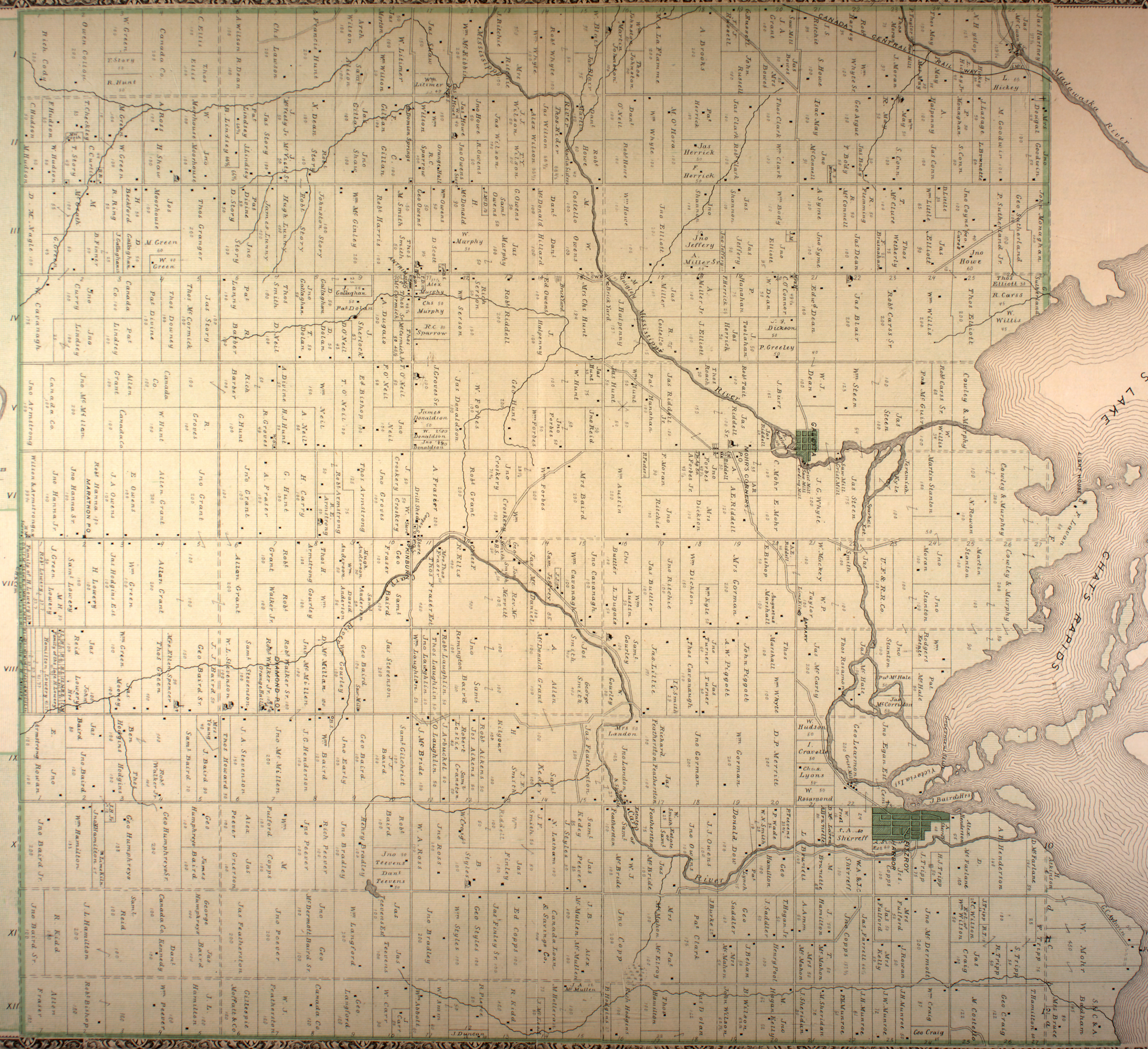
Fortunately for me (now), there's the Canadian County Atlas Digital Project, provided by the Digital Collections Program, Rare Books and Special Collections Division, McGill University, and hosted through McGill library's website.  Originally launched in 1999, the site offers a short history of the county maps and their publishers, a short list of abbreviations, and the ability to order high-resolution copies.  Viewers can search the collection by either a last name (alone or with further qualifiers) or by place (generally by county, by either a clickable map or a list, or more specifically with pull-down lists by county, township, and/or town).

Fitzroy Township, Carleton County, Ontario, Canada.
Map originally published by H. Beldon & Co., Toronto, 1879. 
Image from The Canadian County Atlas Digital Project, McGill University, 2001. 
Accessed 8 December 2010.  Click to enlarge.
View of Concessions III and IV, Lots 5 and 6,
Fitzroy Township, Carleton County, Ontario, Canada.
"Thos. Granger" (blocked out in red) was my great-great-grandfather, "D[avid]. Story" (blocked out in green, but with his Story brothers all around) was Thomas' father-in-law and thus my great-great-great-grandfather, and "R[ichard]. Barber" (blocked out in blue) was also my great-great-grandfather.  Thomas' daughter Linda and Richard's son Michael were my great-grandparents!

For me (a city gal) to not only be able to see the extent of land that my forefathers owned (coupled with descriptions from the agricultural schedule of the 1871 census), but also the proximity that these families lived within each other has always been quite special to me.  Not only were their farms close by, but they most likely attended the same church (St. Mark's Anglican, ironically in the next township and the next county!) and went to the same social functions.  My "people" were farmers, descended from poor protestant Irish, who left Ireland before the famine to eke out a new life in a strange new country.  They didn't get much mention in the "official" record, and I have very little personal artefacts, so any little link to their lives is, for me, quite precious.


Please Note: This challenge was originally published the week of 20 February 2010 at GeneaBloggers.  I'm continuing the series on my own after a lengthy (cough, cough) break from genealogy...

Monday, February 22

52 Weeks to Better Genealogy : Week 7...the results

Amy Coffin of the We Tree blog (and hosted by Geneabloggers) presents "52 Weeks To Better Genealogy", a series of weekly genealogy prompts / suggestions / exercises that (hopefully) will help anyone to become a better researcher.

The challenge for week 7:

Play with Google Maps. This is a helpful tool for determining the locations of addresses in your family history. Where your ancestral homestead once stood may now be a warehouse, a parking lot or a field. Perhaps the house is still there. When you input addresses in Google Maps, don’t forget to use the Satellite View and Street View options for perspectives that put you were right there where your ancestors once stood. If you’ve used this tool before, take sometime and play with it again. Push all the buttons, click all the links and devise new ways it can help with your personal genealogy research. If you have a genealogy blog, write about your experiences with Google Maps, or suggest similar easy (and free) tools that have helped in your own research.

The Results:

I've played with Google Maps (and their neat street views) a few times before at work - and sometimes for work (assisting customer's in finding locations, directions, etc.).  This is the first time I've used Google Maps for my research, and I found a few interesting tidbits...

I first decided to google Arnprior District and Memorial Hospital (in Arnprior, McNab twp., Renfrew co., Ontario, CAN), where I was born.  I found myself in luck - with a street view of the building (and the World War I cenotaph visible in front of the building):

(click any image to enlarge)

(map of the Arnprior area on the Ottawa River with the hospital marked)

(hospital sign, dated (I think) 1945?)

(general view, with the sign to the right - it's a nice, old-fashioned building)

Next, I decided to take a wander "up north" to Cobalt (Bucke twp., Temiskaming dist., Ontario, CAN), where my mother was born and my grandparents (her mother and step-father) still reside.  After my parents divorced, this is were we lived until I started kindergarten.  Lo and behold, guess what I found:

(map of Cobalt and surrounding area)

(my grandparents' house!)

(the United Church where my grandparents were married - since she was Baptist and he was Anglican)

(Cobalt railway station, now "The Bunker", a military museum)

After we left Cobalt, I remember riding the train (the Northlander, which was a 10 hour trip) to visit them, and arriving at this station (when it was still the station) at night.  The train is still my favourite way to travel. 

I then went back to the Ottawa area to look at Kinburn (Fitzroy twp., Carleton co., Ontario, CAN), where my father was born and grew up, my parents lived while they were married, and I spent the first two years of my life.  Unfortunately, google failed me here - there was no option for a street view beyond the major roads:

(map of the Kinburn area)

(satellite image of the Kinburn area; in the top right corner (just hidden) is the Kinburn/Carp intersection...)

(the intersection at Carp Rd. and Kinburn Side Rd., looking towards Kinburn - the closest street view I could get on Google)

52 Weeks to Better Genealogy : Week 8 (the challenge)

Amy Coffin of the We Tree blog presents "52 Weeks To Better Genealogy", a series of weekly genealogy prompts / suggestions / exercises that (hopefully) will help anyone to become a better researcher.

The challenge for week 8:

Discover online map collections. Historical maps are wonderful tools for historical research. Fortunately for genealogists, many map collections are located online. Some of the more prominent collections are: the American Memory Collection at the Library of Congress, the David Rumsey Map Collection, and the Perry-Castañeda Library Map Collection at the University of Texas at Austin. Take some time to browse each of these collections. You may also want to check the library web site of your local university (or one near your ancestral home) to see what maps they may have online. If you have a genealogy blog, write about any special maps you find during this activity.

I'll post my results later this week...

Saturday, February 13

52 Weeks to Better Genealogy : Week 7 - the challenge

Amy Coffin of the We Tree blog presents "52 Weeks To Better Genealogy", a series of weekly genealogy prompts / suggestions / exercises that (hopefully) will help anyone to become a better researcher.

The challenge for week 7:

Play with Google Maps. This is a helpful tool for determining the locations of addresses in your family history. Where your ancestral homestead once stood may now be a warehouse, a parking lot or a field. Perhaps the house is still there. When you input addresses in Google Maps, don’t forget to use the Satellite View and Street View options for perspectives that put you were right there where your ancestors once stood. If you’ve used this tool before, take sometime and play with it again. Push all the buttons, click all the links and devise new ways it can help with your personal genealogy research. If you have a genealogy blog, write about your experiences with Google Maps, or suggest similar easy (and free) tools that have helped in your own research.

I'll post my results later this week...